|
Core Project2. Greenhouse gas observation from space and use of the observations to estimate global carbon flux distribution |
Research Plan > Core Research Projects > 2006 Research Results |
|
[2006 Research Results] |
This project is lead by three research groups and their findings are reflected in the task of the NIES GOSAT Project Office. Key achievements in 2006 are summarized below. |
|
Developing and improving algorithms for processing data obtained from GOSAT |
The major goal of the GOSAT project is to obtain spaceborne carbon dioxide (CO2) and methane (CH4) column abundances accurately. Unlike clear sky conditions, cirrus cloud coverage over the observation points interferes the infrared radiation reaching an instrument onboard the satellite thus skewing the CO2 and CH4 estimates. A novel method was developed to calculate CO2 and CH4 column abundances even if such interferences exist. The spectrometer on the satellite detects infrared radiation in the 2 µm-band, which is strongly absorbed by atmospheric water vapor. We use this 2 µm-band spectral data to estimate the path radiance from the cloud layer. The optical depth and the height of cirrus are estimated from the O2 A-band (0.76 µm) and the water vapor band data. Column abundances of CO2 and CH4 as well as ground surface albedo, are then retrieved simultaneously from the 1.6 µm-band spectral data. |
|
Developing and improving algorithms for processing data obtained from GOSAT |
|
|
|
【Stepwise retrieval method of column abundances of CO2 and CH4 under the cirrus conditions】
STEP 1: The cirrus optical depth and the height of cirrus are retrieved from O2 A-band (0.76 µm-band) and the saturated spectral region by water vapor (2.0 µm-band).
STEP 2: Simultaneous retrieval of column abundances of CO2 and CH4, ground surface albedo, and re-estimation of cirrus optical depth from 1.6 µm-band.
|
|
|
Verification of the GOSAT data retrieval algorithm using an aircraft and in-situ observation points |
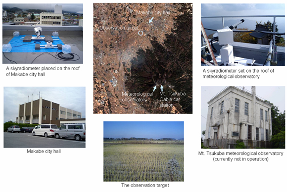
In December 2006, we performed a series of experiments on the summit of Mt. Tsukuba to simulate the conditions of the GOSAT observation. We evaluated the algorithm for deriving CO2 column abundance and assessed the influence of atmospheric aerosols on the CO2 data. |
|
Verification of the GOSAT data retrieval algorithm using an aircraft and in-situ observation points |
|
|
|
CO2 column abundances retrieved with and without scattering effect of aerosol. |
|
|
Comparison of column abundances retrieved by BBM (bread board model of GOSAT instrument) and in-situ observed by a Cessna aircraft.
=> Difference between the retrieved column abundance with/without scattering effect of aerosol is about 0.2 to 0.4 %.
(There still remains large uncertainties in the aerosol model used in the retrieval analysis)
|
|
|
Observation sites and instruments |
|
|
|
|
Developing and using a model to estimate global CO2 flux |
To enhance the accuracy of our inverse model estimates of CO2 fluxes, it is essential to improve the spatial and temporal resolution of our atmospheric tracer transport model. With the latest refinements made in the model, we are now able to simulate CO2 fluxes with a much finer (~0.25º×0.25º) grid. Left figure shows more localized highs and lows of CO2 distribution, including a typhoon-affected distribution near Kyushu-island. This feature does not appear in a simulation with a coarse (~2º ×2º) grid. |
(click to enlarge) |
|
Distribution of CO2 simulated with the transport model with finer (a) and coarse (b) resolutions. (East Asia, August 30, 2002) |
|
We investigated the influence of synoptic scale weather change on column-averaged CO2 concentrations. Figure shows biases in derived CO2 mixing ratios due to varying atmospheric pressure in August over the 1988-2003 period. Our results show that column-averaged CO2 concentration is positively correlated with the varying pressures over Siberia. This finding suggests that, since the GOSAT CO2 measurements require cloud-free conditions usually associated with high pressure systems, weather-related biases need to be carefully treated while processing GOSAT data for global carbon cycle analysis. |
|
(click to enlarge) |
|
Biases in CO2 mixing ratios due to low-pressure systems in August over the 1988-2003 period. Positive values suggest that the CO2 mixing ratio could be low because of a low-pressure system, while negative values suggest higher mixing ratios in a low-pressure system. |
|
|
The GOSAT Data Handling Facility |
The role of the GOSAT Project Office at NIES is to prepare, process, and manage the data required for the analysis, and to act as a liaison with other related organizations. The Office is now preparing GOSAT Data Handling Facility (GOSAT DHF) for data processing, analysis, and distribution. With this facility in operation, the satellite data is to be handled as follows:
1. The Japan Aerospace Exploration Agency (JAXA) receives the raw data collected with GOSAT.
2. The L1 data is forwarded to the GOSAT DHF.
3. At GOSAT DHF the data is convolved with reference data that has been collected from various sources to calculate CO2 and CH4 column abundances.
The higher level (processed and validated) L2, L3, and L4 products are then made available to public users. These products will be stored on a large disk space at GOSAT DHF. |
|
System configuration of GOSAT DHF |
|
(click to enlarge) |
|
|
|