|
 |
|
Core Project2. Greenhouse gas observation from space and use of the observations to estimate global carbon flux distribution |
Research Plan > Core Research Projects > 2009 Research Results |
|
[2009 Research Results] |
This project is being carried out by three research groups, and the results are coordinated by the NIES GOSAT Project Office. The following are the main results obtained in 2009. |
|
Developing and improving algorithms for processing data obtained from satellite |
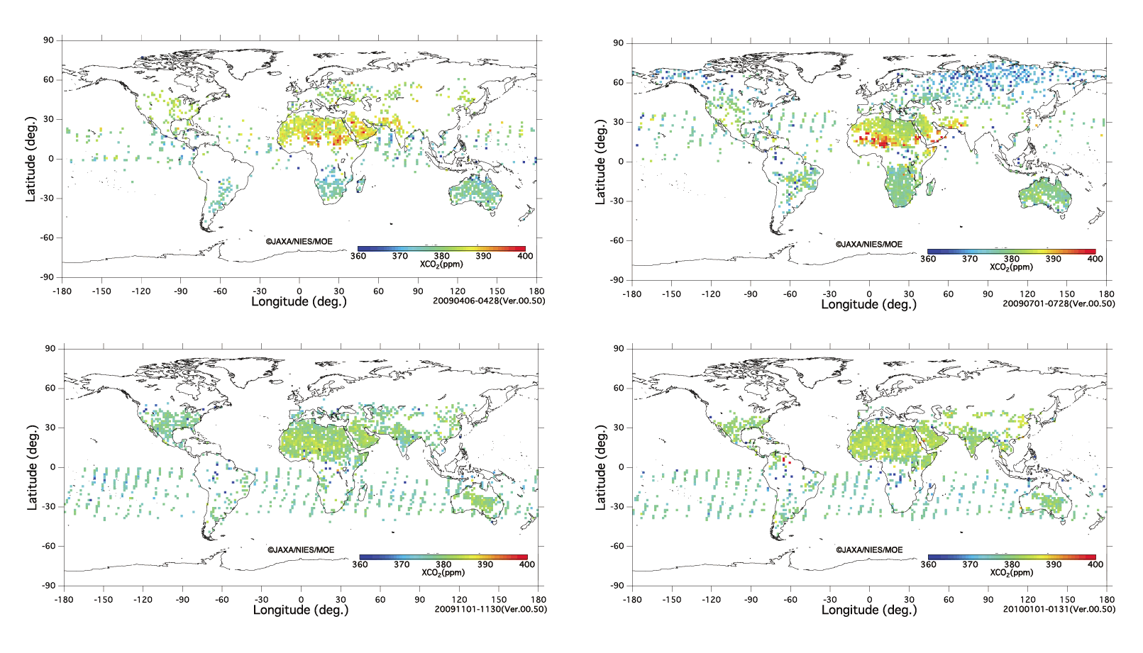
During the first year of observations made by the GOSAT, we derived CO2 and CH4 column abundances from data in cloud-free observation conditions with high signal to noise ratio (over 100). In Figure 1, monthly global maps of the CO2 column-averaged volume mixing ratio (XCO2) can be seen. In the Northern Hemisphere, XCO2 reaches its maximum around April–May, and its minimum around September–October, implying a clear seasonal variation. In the Southern Hemisphere the amplitude of the seasonal variation is smaller. It has been confirmed that the column-averaged volume mixing ratio of methane (XCH4) is higher in the Northern Hemisphere than in the Southern Hemisphere. Although there is a tendency for under-estimation of the obtained column abundance data, its dispersion is within 1–2%. The high concentration around the Sahara is thought to be a bias due to the strong influence of dust particles. We are now making efforts to improve the retrieval algorithm for deriving more accurate column abundances. |
(click to enlarge) |
|
|
Figure 1: Monthly global maps of the CO2 column-averaged volume mixing ratio in 1.5 deg. by 1.5 deg. mesh. |
|
|
Empirical research on analytical methods to derive greenhouse gas levels from aircraft and in-situ observations |
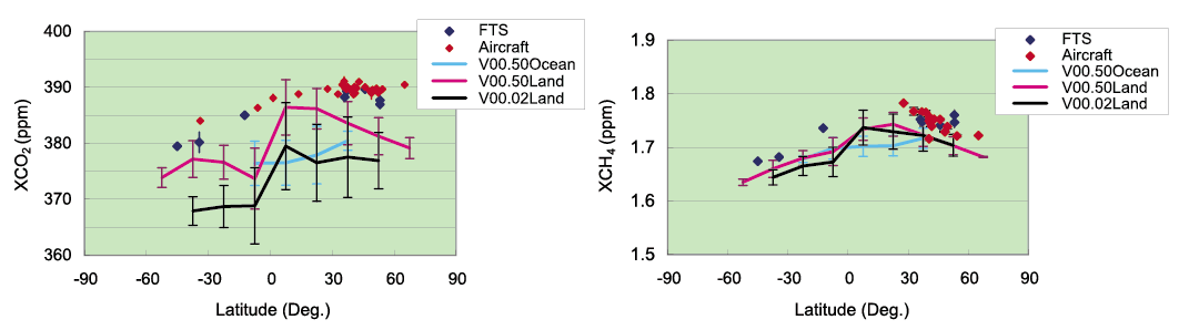
To enable the scientific use of GOSAT products, it is indispensible to compare them with validation data obtained independently from other measuring equipment with less uncertainty, and to analyze possible deviations and biases. As validation data, we used two kinds of data: 1) values derived from column abundance data obtained by a ground-based high-resolution Fourier transform spectrometer, and 2) column abundance data calculated form vertical profiles measured by aircraft.
The verification results of the validation data showed that the uncertainty of XCO2 measured by the ground-based high-resolution Fourier transform spectrometer was 0.3% (1ppm), and that of the observation precision of XCH4 was less than 0.3%. Although the measurement uncertainty of the vertical distribution observed by aircraft was found to be 0.2ppm, the uncertainty, where aircraft measurements were not available and XCO2 was derived from estimates of the vertical distribution, was approximately 1ppm.
Using the above mentioned validation data, we carried out validation of XCO2 and XCH4 values. Compared with the validation data, the column abundances and the column-averaged volume mixing ratios derived from GOSAT observations were 2–3% lower for XCO2. Furthermore, the variability of GOSAT data was larger than that of the validation data. It has also become clear that the column-averaged volume mixing ratios derived from GOSAT data were lower when cloud screening was not sufficient.
In order to overcome these deficiencies of the GOSAT data, we are planning to continue the calibration, algorithm improvement and validation work. |
(click to enlarge) |
|
Figure 2: Latitudinal distribution of column-averaged volume mixing ratios: Comparison between GOSAT data (monthly average of XCO2 to the left and that of XCH4 to the right, –:old version, –:revised version) and validation data (monthly average,  :high-resolution Fourier transform spectrometer, :high-resolution Fourier transform spectrometer,  :aircraft) :aircraft) |
|
|
Development of a global carbon fluxes estimation model |
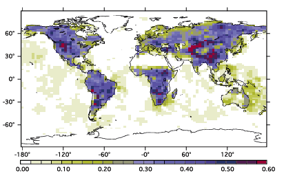
To estimate global surface fluxes of CO2 and CH4 inversely from GOSAT column abundance data, we prepared a priori flux datasets, which are necessary in inverse calculation. For obtaining terrestrial ecosystem fluxes and ocean-atmosphere fluxes, we have developed a vegetation process model and an oceanic tracer transport model. Prior to carrying out the inverse estimation, we evaluated, by using pseudo data, the degree to which the GOSAT column abundance data could reduce uncertainties of current surface flux estimates (Figure 3). For the assessment and selection of the GOSAT column abundance data as the input to the inverse analysis, we have developed a system that calculates climatological column abundances. |
|
|
Figure 3: Decrease in uncertainty of CO2 surface fluxes when GOSAT data are used in the inverse analysis (the larger the value, the larger the decrease in uncertainty) |
|
|
NIES GOSAT Project Office |
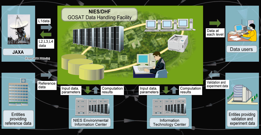
NIES GOSAT Project has developed the GOSAT Data Handling Facility (GOSAT DHF), to where the GOSAT observation data are transferred via JAXA. Its routine tasks include data processing, archiving, and data distribution. Since the processing of the received data and the collected reference data requires a large processing capacity, it is performed by using NIES internal and external computer systems. Some of the typical products are CO2 and CH4 column abundances and their emission and absorption. Cloud and aerosol amounts are also calculated from GOSAT data. After the successful launch of GOSAT on 23 January 2009, these products became available to researchers whose research proposals were accepted by the RA (Research Announcement) Selection and Evaluation Committee as a first step. Level 1 spectral data were released to the general public in October 2009, about 9 months after the launch, and CO2 and CH4 column abundances products in February 2010, about 12 month after the launch. These GOSAT products can be downloaded at the following website:
http://data.gosat.nies.go.jp |
(click to enlarge) |
|
|
Figure 4: Workflow of GOSAT data processing |
|
|
|
|